

Features Loisto Mariner
Loisto Mariner is the best companion to boater: tools for navigation, weather forecast and identifying of other boats with Automatic Identification System (AIS) are always in your pocket!Navigate easily with the Finnish nautical map or hike with precise topographical maps.Loisto Mariner takes you where ever you want to get:• Find your destination with the advanced location search provided by the National Land Survey of Finland.• Enjoy boating also on the lake area – the nautical chart covers Finlands inland waters like Lake Saimaa.• Navigate on Finlands marine area with familiar Finnish nautical charts.• Hike with precise topographical maps.• Plan your routes on land and in the sea.• Check the weather forecast and find a place to rest from a guest harbor.
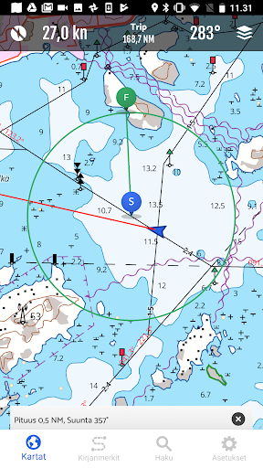
🗺 The clearest and highest quality maps of Finland on the same app.The nautical charts and topographical maps are precise and in vector format.
The nautical charts of the app are based onthe material of the Finnish Transport Infrastructure Agency.Navigational line information is now also available e.g.
from the following lakes: Kivijärvi (Luumäki, Lemi), KareliaPyhäjärvi (Kitee, Parikkala), Pyhäjärvi (Säkylä), Lokka and Porttipahta lakes, Kiantajärvi, Rautavesi-Kulovesi,Ontojärvi, Kyrösjärvi, Keurusselkä, Pyhäjärvi (Iitti), Kimola canal.The general nautical charts cover Åland, Archipelago, Gulf of Finland and Lake Saimaa.
The topographical map is based onthe most accurate material from National Land Survey of Finland.The combined view of the topographical map and nautical charts is even more detailed.You can use the maps also offline.
Save the offline maps to your device and plan routes and navigate successfully, whereever you may roam.
🔍 The advanced search covers thousands of locations.The index is based on the location database of the National Land Survey of Finland.
🚢 The AIS data helps you to identify other boats.
🚤 You can also easily see your current location on the map.
See the maps from the birds-eye view (3D) and you caneasily get a quick glance of your route.With the compass tool, you can measure distances and directions while navigating.
Your track will be visualized on themap as a clearly distinguishable line.
You can decide the length of the direction vector from the settings.
🌐 Plan routes and save your favorite locations.Measure the distances between places, the length of the route and duration of the trip.
You can easily save yourfavorite spots on the map.
⚓ Stop by at the guest harbor.The app helps you to find the guest harbor along the Finnish coastline and on the lakeside.
The services of the harborsare listed.
The information is provided by Suomen Vierassatamat Ltd.
👋
📸Share your location and the spectacular view!You can share your location straight from the app to your favorite social media services.
Choose one of your own imagesor a screenshot from the map to be shared.The weather forecast and coordinates of your location will be shown on the image.
You can start sharing by tapping yourlocation icon on the map.
🌤 Reliable weather forecast always at hand.The local weather forecast is provided by the Finnish Meteorological Institute.
Up-to-date weather forecast requiresthat your device is online.
💶 The yearly subscription fee is only 34,99 €.
Start now navigating with Loisto Mariner!The subscription period is 12 months from the purchase.
The price includes all map updates and app updates.
Thesubscription on Google Play renews automatically unless you unsubscribe.
You can mange your subscriptions by tappingMenu and Subscriptions.Tips for using the app (in Finnish): https://www.loistonavigointi.fi/loisto-marinerContact us or give feedback (in Finnish): https://www.loistonavigointi.fi/tuki-loisto-mariner
Secure & Private
Your data is protected with industry-leading security protocols.
24/7 Support
Our dedicated support team is always ready to help you.
Personalization
Customize the app to match your preferences and workflow.
See the Loisto Mariner in Action


Get the App Today
Available for Android 8.0 and above